Tropical Storm Arthur, the first named storm of the 2026 Atlantic hurricane season, recently impacted the U.S. Gulf Coast, bringing strong winds and heavy rainfall in mid-June. The storm, while remaining below hurricane strength, posed significant risks to coastal areas, especially with predictions of life-threatening flash floods.
Overview of Tropical Storm Arthur
Tropical Storm Arthur was designated as a tropical storm around June 17, 2026, with maximum sustained winds recorded at 40 miles per hour (65 kilometers per hour). The National Hurricane Center reported that tropical-storm-force winds extended up to 175 miles (280 kilometers) from the storm’s center, significantly affecting states along the Gulf Coast. Galveston, Texas, experienced gusts reaching 48 miles per hour, demonstrating Arthur’s potential for causing damage despite not achieving hurricane status.
The impacts of Arthur were primarily felt in terms of heavy rain, raising concerns about flash flooding in southeastern Louisiana, where rainfall rates reached alarming levels of up to 3 inches (7.6 centimeters) per hour. Forecasts hinted that total rainfall in certain areas could exceed 12 inches (30 centimeters), with some locations potentially reaching up to 20 inches (51 centimeters). The National Weather Service has stressed the urgent need for residents to be prepared for possible evacuations.
Effects on the Gulf Coast Region
As Arthur tracked northeast, its heavy rainfall and strong winds disrupted daily life along the Gulf Coast. Local authorities and meteorological services were quick to respond by issuing advisories, urging residents to stay vigilant and take necessary precautions. The storm’s contributions to flooding could have long-term implications for infrastructure, agriculture, and local economies in a region that already grapples with severe weather challenges.
The storm also triggered warnings from the National Weather Service about the potential for life-threatening flash flooding, which can rapidly change over short periods. Moreover, the ongoing moisture delivered by Arthur continues to saturate the area, posing risks of mudslides, road closures, and power outages. The proactive measures taken by local officials have been crucial in minimizing damage and ensuring public safety.
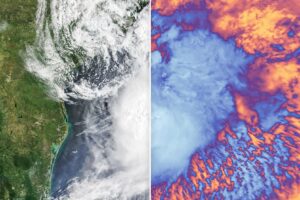
Navigating the Meteorological Insights
NASA’s Terra satellite provided critical insights into Tropical Storm Arthur, capturing both natural-color and infrared images. The natural-color imagery illustrates the distribution of storm clouds over the Gulf Coast, while infrared signals highlight the cooler cloud tops associated with the storm. The satellite data is vital for meteorologists and scientists, enabling them to analyze weather patterns and make accurate predictions for future storms.
Understanding the storm’s structure through advanced satellite technology not only aids immediate response efforts but also contributes to long-term weather forecasting models. These insights can be essential for states along the Gulf Coast as they prepare for future storms and extreme weather events, striving for improved disaster resilience.
Why This Is Trending
The recent developments surrounding Tropical Storm Arthur are garnering attention in India due to several factors. Many Indians have families and business interests in the U.S., particularly in coastal states susceptible to severe weather. Additionally, as climate change brings more unpredictable weather patterns globally, there is growing curiosity about how distant events like Arthur can impact weather ecosystems worldwide. Finally, the intersection of natural disasters and technological advancements in monitoring offers fascinating insights that resonate with India’s own challenges in weather forecasting and disaster preparedness.
Frequently Asked Questions
What was the maximum wind speed of Tropical Storm Arthur?
The maximum sustained wind speed recorded for Tropical Storm Arthur was 40 miles per hour (65 kilometers per hour).
How much rainfall was predicted in areas affected by the storm?
Total rainfall amounts were forecasted to exceed 12 inches (30 centimeters) in certain areas, with some locations potentially seeing totals approaching 20 inches (51 centimeters).
Which states were affected by Tropical Storm Arthur?
The storm primarily affected the U.S. Gulf Coast, with significant impacts reported in Texas and Louisiana.
What technology did NASA use to monitor the storm?
NASA’s Terra satellite was employed to capture natural-color and infrared images of Tropical Storm Arthur, providing critical data for meteorologists.