
Severe weather has recently impacted Louisiana and Mississippi, with flash flooding and severe thunderstorms expected to affect the region. Residents are advised to stay updated on weather warnings as conditions develop throughout the day.
Current Weather Warnings and Advisories
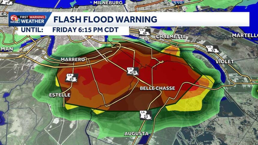
As severe storms progress over the New Orleans Metro area, local authorities have issued several warnings for affected regions. Notably, a Flash Flood Warning is in effect for Northeastern Jefferson Parish, Orleans Parish, and Plaquemines Parish until 6:15 p.m. This warning indicates that rapid flooding could occur, posing risks to life and property.
Additionally, a Severe Thunderstorm Warning has been declared for New Orleans and surrounding areas—including Jefferson Parish, St. Bernard Parish, St. Tammany Parish, and Hancock County, Mississippi—lasting until 4:30 p.m. These advisories are part of a heightened alert for severe weather conditions in southeast Louisiana and south Mississippi.
Weather Forecast and Expected Threats
The weather forecast suggests a slight risk of severe storms today, categorized as a level 2 threat. Isolated to scattered severe storms are expected to develop later in the afternoon and early evening. Radar observations indicate an upper-level disturbance combined with an approaching cold front, fostering conditions conducive to severe storm activity.
Key threats include gusty winds, potential flooding, and heavy rain. A level 1 marginal risk of flooding is currently applicable to southeast Louisiana and south Mississippi, where strong storms could lead to isolated flooding events.
Timing of Severe Weather Events
Residents are advised to prepare for severe weather starting from late afternoon, particularly between 4 p.m. and 6 p.m., when strong to severe storms are likely to develop in South Mississippi and the Northshore region. By 6 p.m. to 8 p.m., a strong line of storms is expected to push into the New Orleans Metro and River Parishes.
Finally, from 9 p.m. to 10 p.m., the line of storms will move toward the Bayou and coastal parishes, while possibly weakening in intensity. It is essential for the community to stay informed as the weather situation is dynamic and subject to change.
Why This Is Trending
This weather situation is gaining traction in India primarily due to increased global interest in severe weather events. With many regions experiencing atypical weather patterns, Indian audiences are keen to understand how these conditions could affect global climate scenarios. Moreover, natural disasters like floods and storms serve as critical reminders of climate change’s far-reaching impacts, urging for a more profound discussion on environmental issues. Indian media outlets are also providing updates as part of a broader narrative on global weather phenomena and their implications.
Frequently Asked Questions
What regions are under the current Flash Flood Warning?
Northeastern Jefferson Parish, Orleans Parish, and Plaquemines Parish are currently under a Flash Flood Warning until 6:15 p.m.
What should residents do during severe weather warnings?
Residents are advised to stay indoors, avoid unnecessary travel, and monitor local news for updates. It’s essential to prepare an emergency kit and have a plan in place in case conditions worsen.
What are the main threats associated with today’s storms?
The primary threats include damaging winds, heavy rainfall leading to isolated flooding, and potential disruptions in services. A level 1 marginal risk of flooding is in effect for the region.
When will weather conditions start improving?
Conditions are expected to improve after 10 p.m. as the line of storms moves out of the metro area, though some weakening may occur.