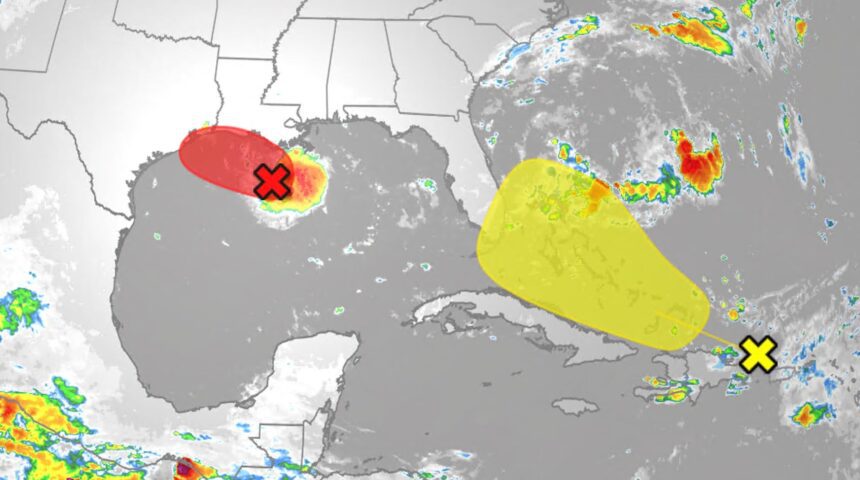

The Gulf Coast is currently on alert as a potential tropical storm named Edouard could develop this week, bringing heavy rainfall to parts of Louisiana and Texas. Additionally, remnants of Tropical Storm Dolly, which has already transitioned into an open wave, may affect Florida and the Caribbean with much-needed rainfall.
Potential Impacts of Tropical Storm Edouard
The National Hurricane Center has been monitoring an area of low pressure over the Gulf, indicating that tropical development could occur as early as today. While the system is expected to make landfall by tonight or tomorrow morning, weather experts emphasize that the impacts, such as heavy rains and wind, will be felt regardless of whether it officially acquires the name Edouard.
Rainfall is anticipated along the Texas and Louisiana coasts, which could accumulate several inches. Most notably, the Hurricane Hunters are scheduled to investigate this weather system today to gather more accurate data.
The Outlook on Dolly’s Remnants
Initially forming on Thursday, Tropical Storm Dolly has transitioned back into an open wave as of Friday morning. Despite the loss of its tropical storm status, Dolly’s remnants are still producing beneficial rains across the Caribbean, particularly in areas facing drought conditions like Puerto Rico and the Virgin Islands.
The National Hurricane Center has indicated a slim chance of Dolly redeveloping into a tropical storm, yet the rich moisture could provide relief amidst a grim rainfall forecast for September. The influence of Dolly will be felt in the Leeward Islands, which can expect locally heavy rain and gusty winds over the next few days.
Potential for Future Development
Models suggest that there may be a chance for Dolly’s remnants to regain strength as they move westward next week. Factors such as wind shear and land interaction with the mountainous terrains of Puerto Rico and Hispaniola will pose challenges for redevelopment.
For those tracking tropical weather patterns, understanding the probabilistic models will be essential. With El Niño affecting the Caribbean, storms may have a harder time developing in the short term. Nonetheless, some forecasts indicate a favorable environment for redevelopment in the eastern Gulf or western Atlantic.
Why This Is Trending
Interest in tropical storms, particularly Edouard and Dolly, has surged, particularly among residents in coastal areas who are acutely aware of their vulnerability to natural disasters. Many are concerned about the potential for heavy rainfall leading to flash floods and landslides. Additionally, the need for rainfall in drought-stricken areas like the Caribbean has drawn attention to Dolly’s remnants, making it a topic of widespread relevance.
Frequently Asked Questions
What is the current status of Tropical Storm Edouard?
The National Hurricane Center is monitoring an area of low pressure in the Gulf of Mexico that could become Tropical Storm Edouard, potentially impacting Louisiana and Texas with heavy rainfall.
How is the situation regarding Dolly’s remnants?
Dolly has returned to an open wave and is no longer a tropical storm, but it is contributing moisture to areas in the Caribbean suffering from drought.
What areas are most at risk from these storms?
Coastal regions of Texas and Louisiana are at high risk for rain and flooding from Edouard, while the Leeward Islands and Puerto Rico may experience heavy rains and gusty winds from Dolly’s remnants.
Are tropical storms common during this time of year?
Yes, the Atlantic hurricane season typically peaks around September. It is common to see multiple tropical systems developing during this timeframe.