
Residents of south central Pennsylvania should be prepared for a day of scattered showers and thunderstorms this Thursday, with localized heavy rainfall raising concerns for flash flooding. As temperatures drop to the 70s, the region will see a mix of humidity and potential severe weather, prompting the National Weather Service to issue a Flood Watch.
Weather Outlook for Thursday
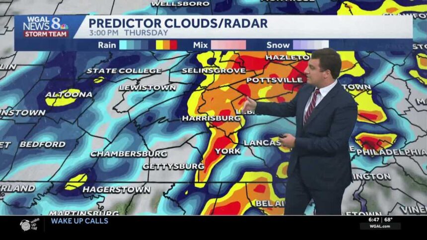
On Thursday morning, the weather will begin with light showers that are expected to develop late in the early hours and continue through late morning. As the day progresses, temperatures will hover in the 70s, accompanied by an increase in humidity. By afternoon, a line of thunderstorms is likely to move into the Susquehanna Valley from the west, making Thursday an impactful weather day.
Heavy downpours could inundate localized areas, with specific counties like Adams, Cumberland, Franklin, Juniata, Mifflin, and Perry under a Flood Watch until 4 PM Thursday. The National Weather Service has indicated that the concern for flash flooding is particularly acute in low-lying regions with inadequate drainage systems.
Severe Weather Risks
As the day unfolds, isolated strong thunderstorms with gusty winds are likely, particularly in the afternoon and early evening hours between 12 PM and 7 PM. The Storm Prediction Center has specifically highlighted areas along and east of I-81 for potential severe weather, with the highest risk observed south and along Route 30 in York County, including major towns like Elizabethtown and Lititz. Residents in these areas should remain vigilant, as the situation could rapidly change.
Overall, the entire Susquehanna Valley is at a marginal risk (level 1 out of 4) for isolated flash flooding, marking it as a day of caution for those living in vulnerable areas.
Looking Ahead: Weather Changes
In stark contrast to Thursday’s wet conditions, the following day, Friday, is expected to bring dry weather along with plenty of sunshine and a few passing clouds. High temperatures will rise to the low 80s, accompanied by a drop in humidity, creating a refreshing atmosphere as dew points plunge into the 50s.
The weekend will not be entirely stable, as low pressure developing over the Mid-Atlantic could result in additional showers and thunderstorms on both Saturday and Sunday. With a cold front moving in on Sunday, temperatures will balance out around 80 degrees. Following this unsettled weekend, residents can expect a cooler and more comfortable week ahead with highs remaining in the upper 70s to near 80 degrees.
Why This Is Trending
The rising search interest in weather patterns is often driven by extreme events and forecasts that could impact daily life. With climate change leading to more unpredictable weather, Indians are increasingly vigilant about weather updates, especially since many individuals have friends or relatives living abroad who are affected by the same patterns. The looming threat of severe weather in Pennsylvania during a time when many people are planning vacations or outdoor activities also makes this topic particularly relevant. Increased interest is notable in updates on weather safety, as individuals seek assurance and preparedness strategies to tackle storms that may arise.
Frequently Asked Questions
What does the Flood Watch mean for residents?
A Flood Watch indicates that conditions are favorable for flooding in the specified area. Residents are advised to stay alert to weather updates and be prepared for possible impacts.
When is the best time to prepare for severe weather?
It is recommended to prepare for severe weather well in advance of the storm. Monitoring weather updates throughout the day will provide the best guidance on when to take action.
What should I do if I encounter flash flooding?
If you encounter flash flooding, it is critical to move to higher ground immediately. Never attempt to drive through flooded roads, as even a small amount of water can sweep a vehicle away.
Will the weather improve over the weekend?
While the weekend will see unsettled conditions with possible showers and thunderstorms, it will also be coupled with moderate temperatures around 80 degrees, providing a slight reprieve from the week’s earlier storms.