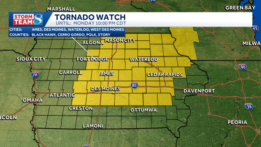

As severe storms sweep through Iowa, a Tornado Watch is in effect until 10 p.m. tonight, impacting central and eastern regions, including the Des Moines metro. With temperatures soaring and humidity at peak levels, the state faces widespread heat indices of 100-105°F, making it important for residents to stay informed and prepared for severe weather conditions.
Severe Weather Conditions in Iowa
Iowa is currently experiencing extreme weather, with a Tornado Watch affecting much of central and eastern Iowa. The intense heat is predicted to peak Monday afternoon, with temperatures reaching the mid-90s and a corresponding rise in humidity. This combination has led to heat indices around 105°F, prompting authorities to issue a Heat Advisory until 8 p.m.
As the temperatures increase, development of strong thunderstorms is anticipated, particularly during the evening hours. These storms are expected to cross the state late afternoon into the evening, with forecasts indicating possible damaging wind gusts and large hail, including some reports of baseball-sized hail already emerging in parts of Iowa.
Impact of Thunderstorms and Associated Risks
The current storm system moving through Iowa presents significant risks, particularly in the form of damaging winds and hail. Meteorologists have warned that winds could reach speeds of 60-75 mph. A clear cluster of storms is currently impacting areas such as Ames and Huxley, with severe thunderstorm warnings issued for multiple counties.
These storms are more severe than earlier systems in the day. For residents, the primary concern is the potential for high wind gusts, which can cause tree damage and power outages, as well as large hail that may damage vehicles and crops. Additionally, a tentative tornado threat looms for eastern portions of the state as conditions remain favorable for tornado formation.
Weather Relief on the Horizon
Interestingly, while the heat continues to rise today, the incoming thunderstorms are expected to bring cooler temperatures in their aftermath. The storms will usher in a drop in temperatures, with expected lows in the 60s and 70s overnight, providing much-needed relief from the heat. The forecast for Tuesday suggests a return to more comfortable temperatures, with a high around 84°F.
This cooling trend is essential as the region has been enduring extreme heat, making it vital for residents to stay hydrated and follow local advisories. There are also indications of wildfire smoke that could linger into Tuesday morning; however, this should not be as thick as earlier in the week.
Why This Is Trending
Indian readers are increasingly concerned about extreme weather events globally, sparked by recent high-profile occurrences of severe storms and climate-related disasters. As weather patterns change and intensify, many are searching for reliable information on how to stay safe during similar weather events. Awareness of extreme heat and tornado risks also resonates deeply with communities in India, where they experience intense heat waves and monsoon impacts. This interconnectivity of weather challenges fosters a heightened awareness and interest in updates pertaining to severe weather across the globe, including places like Iowa.
Frequently Asked Questions
What is a Tornado Watch?
A Tornado Watch means that conditions are favorable for tornadoes to develop in the area. It is an alert for residents to stay vigilant and prepared for possible severe weather.
What are the expected impacts of the ongoing storms?
The storms are likely to bring high winds, hail, and increased risk for tornado formation in certain areas. Residents should take precautions and stay updated on local weather reports.
How can I stay safe during severe weather conditions?
Stay indoors during the storm, avoid windows, and have an emergency kit ready. It’s also essential to have a way to receive weather alerts, such as a weather app or a NOAA radio.
Will tomorrow’s weather be cooler?
Yes, the incoming storms are expected to lower temperatures significantly, providing relief from the current heat, with highs anticipated around 84°F.